Mission | Remote Sensing |
Weight | 650 Kg |
Onboard Orbit | 900 Watts |
Stabilization | 3 - axis body stabilised using high torque reaction wheels, magnetic torquers and thrusters |
Payloads | Panchromatic Camera |
Launch date | 10 January 2007 |
Launch site | SHAR Centre Sriharikota India |
Launch vehicle | PSLV- C7 |
Orbit | Polar Sun Synchronous |
Mission life | 5 years |
Thursday, September 9, 2010
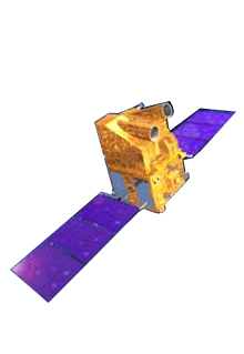
CARTOSAT - 2
CARTOSAT - 2 Launch Date 10.01.2007
Wednesday, September 8, 2010
CARTOSAT - 1
CARTOSAT - 1 Launch Date05.05.2005
CARTOSAT – 1 is the first India Remote Sensing Satellite capable of providing in-orbit stereo images. The images are used for Cartographic applications meeting the global requirements. Cameras of this satellite have a resolution of 2.5m (can distinguish a small car).
The Cartosat – 1 provides stereo pairs required for generating Digital Elevation Models, Ortho Image products, and Value added products for various applications of Geographical Information System (GIS).
Launch date | 5 May 2005 |
Launch site | SHAR Centre Sriharikota India |
Launch vehicle | PSLV- C6 |
Orbit | 618 km Polar Sun Synchronous |
Payloads | PAN FORE, PAN – AFT |
Orbit Period | 97 min |
Number of Orbits Per day | 14 |
Local time of equator crossing | 10:30 am |
Repetivity | 126 days |
Revisit | 5 days |
Lift-Off mass | 1560 kg |
Attitude and orbit control | 3-axis body stabillised using reaction wheels, Magnetic Torquers and Hydrazine Thrusters |
Electrical power | 15 sqm Solar Array generating 1100w, Two 24 Ah Ni-Cd batteries |
Mission life | 5 years |
Monday, September 6, 2010
IRS P6 / RESOURCESAT-1
IRS P6 / RESOURCESAT-1 Launch Date 17.10.2003
RESOURCESAT-1 is the tenth satellite of ISRO in IRS series, intended to not only continue the remote sensing data services provided by IRS-1C and IRS-1D, both of which have far outlived their designed mission lives, but also to vastly enhance the data quality. RESOURCESAT-1 is the most advanced Remote Sensing Satellite built by ISRO as of 2003.
Launch date | October 17, 2003 |
Launch site | SHAR, Sriharikota |
Launch vehicle | PSLV-C5 |
Payloads | LISS-4, LISS-3, AWiFS-A, AWiFS-B |
Orbit | Polar Sun Synchronous |
Orbit height | 817 km |
Orbit inclination | 98.7o |
Orbit period | 101.35 min |
Number of Orbits Per day | 14 |
Local time of equator crossing | 10:30 am |
Repetivity (LISS-3) | 24 days |
Revisit | 5 days |
Lift-Off mass | 1360 kg |
Attitude and orbit control | 3-axis body stabilised using Reaction Wheels, Magnetic Torquers and Hydrazine Thrusters |
Power | Solar Array generating 1250 W, Two 24 Ah Ni-Cd batteries |
Mission Life | 5 years |
Saturday, September 4, 2010
Technology Experiment Satellite (TES)
Technology Experiment Satellite (TES) Launch Date 22.10.2001
The Technology Experiment Satellite (TES), weighing 1108 kg, was launched on October 22,2001. TES is an experimental satellite to demonstrate and validate the technologies like attitude and orbit control system, high-torque reaction wheels, new reaction control system, light-weight spacecraft structure, solid state recorder, X-band phased array antenna, improved satellite positioning system, miniaturised TTC and power systems and, two-mirror-on-axis camera optics.
TES also carried a panchromatic camera for remote sensing experiments.
Launch date | 22 October 2001 |
Launch site | SHAR Centre Sriharikota India |
Launch vehicle | PSLV- C3 |
Orbit | 572 kms Sun Synchronous |
Payloads | PAN |
Friday, September 3, 2010
IRS-P4 Ocean Sat
IRS-P4 Ocean Sat Launch Date 26.05.1999
IRS-P4 (OCEANSAT) is the first satellite primarily built for Ocean applications, weighing 1050 kg placed in a Polar Sun Synchronous orbit of 720 km, launched by PSLV-C2 from SHAR Centre, Sriharikota on May 26, 1999.
This satellite carries Ocean Colour Monitor (OCM) and a Multi - frequency Scanning Microwave Radiometer (MSMR) for oceanographic studies. IRS-P4 thus vastly augment the IRS satellite system of ISRO comprising four satellites, IRS-1B, IRS-1C, IRS-P3 and IRS-1D and extend remote sensing applications to several newer areas.
Launch date | May 26, 1999 |
Launch site | SHAR, Sriharikota |
Launch vehicle | PSLV - C2 |
Orbit | Polar Sun Synchronous |
Altitude | 720 km |
Inclination | 98.28 deg |
Period | 99.31 min |
Local time of Eq. crossing | 12 noon |
Repetitivity cycle | 2 days |
Size | 2.8m x 1.98m x 2.57m |
Mass at lift off | 1050 kg |
Length when fully deployed | 11.67 m |
Attitude and Orbit Control | 3-axis body-stabilised using Reaction Wheels, Magnetic Torquers and Hydrazine Thrusters |
Power | 9.6 Sq.m Solar Array generating 750w Two 21 Ah Ni-Cd Battries |
Mission Life | 5 years |


