Pages

Friday, December 16, 2011

GSAT-12 Communication Satellite placed in Geosynchronous Orbit


The GSAT-12 Communication Satellite, launched onboard Polar Satellite Launch Vehicle (PSLV-C17), has been successfully located in Geosynchronous Orbit with a perigee of 35,684 km, apogee of 35,715 km and an orbital inclination of 0.17 degree with respect to the equatorial plane.

It may be recalled that on July 15, 2011, PSLV-C17 had injected GSAT-12 into an elliptical transfer orbit of 281 km perigee and 21,027 km apogee, and orbital inclination of 17.9 degree. The critical manoeuvres to raise GSAT-12 Satellite into Geosynchronous Orbit were performed by firing the 440 Newton Liquid Apogee Motor of GSAT-12 Satellite for about 80 minutes in five spells during July 16-20, 2011.

The Communication antenna onboard the satellite was deployed successfully today (July 21, 2011) at 15:30 hrs (IST) and the Satellite is in its final orbital configuration, pointing towards Earth.

GSAT-12 is now located at 63 degree East longitude. The Satellite would be moved to reach its designated longitude of 83 degree East within the next 16 days (at the rate of one degree per day). The GSAT-12 Satellite will be co-located with INSAT-2E and INSAT-4A Satellites.

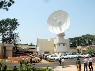
After parking the Satellite at this location, the Communication Transponders are planned to be switched on by August 5, 2011, followed by In-Orbit Testing. The GSAT-12 Satellite is in good health and is in continuous radio-visibility from ISRO's Master Control Facility, Hassan.

Friday, November 4, 2011

YOUTHSAT Satellite


YOUTHSAT is a joint Indo-Russian stellar and atmospheric satellite mission with the contribution of students from Universities at graduate, post graduate and research scholar level. With a lift-off mass of 92 kg, Youthsat is a mini satellite and the second in the Indian Mini Satellite (IMS) series.

Youthsat mission intends to investigate the relationship between solar variability and thermosphere-Ionosphere changes.

The satellite carries three payloads, of which two are Indian and one Russian. Together, they form a unique and complete package of experiments for the investigation of the composition, energetics and dynamics of earth's upper atmosphere.

The Indian payloads are:
RaBIT (Radio Beacon for Ionospheric Tomography) - For mapping Total Electron Content (TEC) of the Ionosphere.

LiVHySI (Limb Viewing Hyper Spectral Imager) - To perform airglow measurements of the Earth's upper atmosphere (80- 600 km) in 450-950 nm.

The Russian payload.

SOLRAD - To study temporal and spectral parameters of solar flare X and gamma ray fluxes as well as charge particles in the earth polar cap regions.

Monday, September 26, 2011

Data Reception and Dissemination


National Remote Sensing Centre (NRSC) is responsible for remote sensing satellite data acquirement and processing, data dissemination, aerial remote sensing and decision support for disaster management.

NRSC has archived a wealth of satellite images from Indian and foreign satellites since 1983. NRSC has its data reception facility at Shadnagar, 65 km from Hyderabad city. The station has four state of the art antenna systems for data reception and archival.

The Satellite data processing chain has a user friendly web mechanism to enable users to order data of their requirement. It can facilitate to acquire data pertaining to any part of the globe on user request.

The Aerial facility has two Beech craft aircraft to acquire data utilizing various sensors like Aerial cameras, Laser instrument, Synthetic aperture radar and Magnetometer.

The aerial facility has carried out number of studies for mapping and infrastructure planning for towns and cities, Cadastral surveys, canal alignment for interlinking of rivers, Digital elevation model (DEM) applications ,Mineral targeting etc., It has also carried out international projects in Maldives & Emirates of Dubai.

The Decision Support Centre (DSC) is a single window information provider on major natural disasters like Floods, Agricultural Drought, and Forest fires, Cyclones, Earthquakes and Landslides. It provides near real time information to State and Central government for relief, rehabilitation and planning. The DSC also supports International Charter on Space and Major Disasters and Sentinel Asia. Under this, critical support was extended to Myanmar during Nargis (2008) Cyclone; Indonesian floods (2008) and China earthquake (2008).

Tuesday, August 30, 2011

India's First Mission to Moon


“THE MOON “with the history of the early solar system etched on it beckons mankind from time immemorial to admire its marvels and discover its secrets. Understanding the moon provides a pathway to unravel the early evolution of the solar system and that of the planet earth.

Through the ages, the Moon, our closest extraterrestrial body has aroused curiosity in our mind much more than any other objects in the sky. This led to scientific study of the Moon, driven by human desire and mission for knowledge. This is also reflected in the ancient verse.

Exploration of the moon got a boost with the advent of the space age and the decades of sixties and seventies saw a myriad of successful unmanned and manned missions to moon. This was followed by a hiatus of about one and a half-decade. During this period we refined our knowledge about the origin and evolution of the moon and its place as a link to understand the early history of the Solar System and of the earth.

However, new questions about lunar evolution also emerged and new possibilities of using the moon as a platform for further exploration of the solar system and beyond were formulated. Moon again became the prime target for exploration and a new renaissance of rejuvenated interest dawned. All the major space faring nations of the world started planning missions to explore the moon and also to utilize moon as a potential base for space exploration.

The idea of undertaking an Indian scientific mission to Moon was initially mooted in a meeting of the Indian Academy of Sciences in 1999 that was followed up by discussions in the Astronautical Society of India in 2000. Based on the recommendations made by the learned members of these forums, a National Lunar Mission Task Force was constituted by the Indian Space Research Organization (ISRO). Leading Indian scientists and technologists participated in the deliberations of the Task Force that provided an assessment on the feasibility of an Indian Mission to the Moon as well as dwelt on the focus of such a mission and its possible configuration.

Wednesday, August 3, 2011

Village Resource Centres


To provide services space allowed directly to the rural population, ISRO launched the Village Resource Centre (VRC) program in partnership with renowned NGOs / trusts and state agencies / central.

VRC 473 were established in 22 territories of the States / Union, namely, Andhra Pradesh, Assam, Bihar, Delhi, Gujarat, Himachal Pradesh, Jharkhand, Karnataka, Kerala, Madhya Pradesh, Maharashtra, Meghalaya, Nagaland, Orissa, Pondicherry, Rajasthan, Sikkim. Tamil Nadu, Uttarakhand, Uttar Pradesh, West Bengal and A & N Islands.

The VRC is connected to the centers of knowledge / experts and agricultural universities, institutes of Skills Development and Hospitals. More than 6500 programs have been conducted by the VRC in the areas of skills development for agriculture / horticulture, fisheries, livestock, water resources, Tele health care, awareness programs, empowerment of women, education further, computer literacy, micro credits, micro finance / professional training for livelihood support, etc. So far, more than five lakh people have benefited from the services of VRC.

Thursday, July 21, 2011

About Disaster Management


The Disaster Management Support (DMS) Programme of ISRO, provides timely support and services from aero-space systems, both imaging and communications, towards efficient management of disasters in the country. The DMS programme addresses disasters such as flood, cyclone, drought, forest fire, landslide and Earthquake etc.

These include design of digital data base for facilitating hazard zonation, damage assessment, etc., monitoring of major natural disasters using satellite and aerial data; development of suitable techniques and tools for decision support, establishing satellite based reliable communication network, deployment of emergency communication equipments and R&D towards early warning of disasters.

To support the total cycle of disaster/ emergency management for the country, in near real time, the database creation is addressed through National Database for Emergency Management (NDEM), a GIS based repository of data. NDEM is envisaged to have core data, hazard-specific data, and dynamic data in spatial as well as aspatial form.

Monday, July 11, 2011

Remote Sensing Applications

Remote sensing has enabled mapping, studying, monitoring and management of various resources like agriculture, forestry, geology, water, ocean etc. It has further enabled monitoring of environment and thereby helping in protection. In the last four decades it has grown as a major tool for collecting information on almost every aspect on the earth.

With the availability of very high spatial resolution satellites in the recent years, the applications have multiplied. In India remote sensing has been used for various applications during the last four decades and has contributed considerably towards development.

India has its own satellites like Indian Remote Sensing Satellite (IRS) series - Resourcesat, Cartosat, Oceansat etc which provide required data for carrying out various projects. Some of the important projects carried out in the country include Groundwater Prospects Mapping under Drinking Water Mission, Forecasting Agricultural output using Space, Agro meteorology and Land based observations (FASAL), Forest Cover/Type Mapping, Grassland Mapping, Biodiversity Characterisation, Snow & Glacier Studies, Land Use/Cover mapping, Coastal Studies, Coral and Mangroves Studies, Wasteland Mapping etc.

The information generated by large number of projects have been used by various departments, industries and others for different purposes like development planning, monitoring, conservation etc.

Monday, June 20, 2011

Satcom Application


Satellite Communication (Satcom) technology offers the unique capability of at the same time reaching out to very large numbers spread over large distances even in the most remote corners of the country. The hallmark of Indian Space Programme has been the application oriented efforts and the benefits that have accrued to the country.

In the past two and a half decades Indian National Satellite (INSAT) system have revolutionized the country’s telecommunications, TV broadcasting, DTH services, business communications, rural area connectivity, Tele-education, Tele-medicine, Village Resource Centers, Search and Rescue operations and Emergency Communications.

INSAT system is a joint venture of the Department of Space, Department of Telecommunications, India Meteorological Department, All India Radio and Doordarshan. Established in 1983, INSAT system is one of the largest domestic communication satellite systems in the Asia Pacific Region with eleven satellites in operation. These satellites carry more than 200 transponders in the C, Extended C and Ku-bands, besides meteorological instruments.
INSAT is used for a variety of societal applications in the area of Tele-education, Tele-medicine and support to the Disaster Management System (DMS).

Village Resource Centre (VRC), a single window agency providing the services offered by INSAT and IRS satellites to provide information on natural resources, land and water resources management, Tele-medicine, Tele-education, adult education, vocational training, health-care and family welfare programmes, has been established. Meteorological data from INSAT is used for weather forecasting and specially designed disaster warning receivers have been installed in vulnerable coastal areas for direct transmission of warnings against impending disaster like cyclones.

Wednesday, April 27, 2011

Sponsord Research


The Indian Space Research Organization (ISRO) has evolved a programme through which financial support is provided for conducting research and development activities related to Space Science, Space Technology and Space Application to academia in India.

This programme of Research Sponsored by ISRO is called RESPOND. In special cases research and development projects proposed by non-academic R & D laboratories can also be supported through this programme. The aim of RESPOND is to encourage quality research in areas of relevance to the Indian space programme.

The primary objective of the Indian Space programme is to harness the advanced research areas of space science and technology for national development and to derive the maximum benefit for the people of India.

The Indian Space Programme includes the following major elements:
Demonstration of the feasibility of deriving from space science and technology, applications in space communications, long distance education, earth resources survey, meterology and geodesy.

Development of indigenous capability for design and development of orbiting satellites for scientific research and space applications, sounding rockets and satellite launch vehicles.

Wednesday, April 13, 2011

Space vision


* Satellite based communication and direction-finding systems for rural connectivity, security needs and mobile services

* Enhanced imaging capability for natural resource management, weather and climate change studies

* Space science missions for better understanding of solar system and universe

* Planetary exploration

* Development of Heavy lift launcher

* Reusable Launch Vehicles - Technology demonstrator missions leading to Two Stage to Orbit (TSTO)

* Human Space Flight

Wednesday, April 6, 2011

SERVICES PROVIDED BY THE DEPARTMENT


The Department of Space is committed to :

Provide national space infrastructure for the telecommunication needs of the country.
  • Provide satellite services required for weather forecasting, monitoring etc.
  • Provide satellite imagery required for the developmental and security needs of the country.
  • Provide satellite imagery and specific products and services required for application of space science and technology for developmental purposes to the Central Government, State Governments, Quasi Governmental Organizations, NGOs and the private sector.
  • Promote Research & Development in space sciences and technology.
While operationalizing the above mentioned objectives, Department of Space will

  • Provide required transponders and facilities out of its own capacity as well as by hiring additional capacity, if needed.
  • Register Indian Satellite System for public and private sectors.
  • Provide its products and services in a prompt, efficient and corruption free manner to all the users/clients.

Monday, March 28, 2011

Antrix Corporation Limited


Antrix Corporation Limited is an entirely owned by Government of India Company under the administrative control of the Department of Space, Government of India. Antrix Corporation Limited was incorporated as a private limited company owned by Government of India, in September 1992 as a Marketing arm of Indian Space Research Organization (ISRO) for promotion and commercial exploitation of space products, technical consultancy services and transfer of technologies developed by ISRO. Another major objective is to facilitate development of space related industrial capabilities in India.

As the commercial & marketing arm of Indian Space Research Organization (ISRO), Antrix is engaged in providing Space products & services to international customers worldwide. Antrix, which is an INR 950 Cr. Company in 2007-08, got the "Miniratna" status by the Government of India in 2008.

With fully equipped state-of-the-art facilities, Antrix is a one-stop-shop for any of the space products, ranging from supply of hardware and software including simple subsystems to a complex spacecraft, for varied applications covering communications, earth observation, scientific missions; space related service including remote sensing data series, Transponders lease service; Launch services through the operational launch vehicles (PSLV and GSLV); Mission support services; and a host of consultancy and training services are also offered by Antrix.

With the versatility of products and services being marketed, Antrix caters to a prestigious clientele including some of the leading space companies across the globe - EADS Astrium, Intelsat, Avanti Group, World space, Inmarsat, World Sat, DLR, KARI, Eutelsat, OHB Systems and several other Space Institutions in Europe, Middle East and South East Asian countries.

Thursday, March 24, 2011

Data reception & dissemination


National Remote Sensing Centre (NRSC) is responsible for remote sensing satellite data acquisition and processing, data dissemination, aerial remote sensing and decision support for disaster management.

NRSC has archived a prosperity of satellite images from Indian and foreign satellites since 1983. NRSC has its data reception facility at Shadnagar, 65 km from Hyderabad city. The station has four state of the art antenna systems for data reception and archival.

The Satellite data processing chain has a user friendly web mechanism to enable users to order data of their requirement. It can facilitate to acquire data pertaining to any part of the globe on user request.

The Aerial facility has two Beech craft aircraft to acquire data utilizing various sensors like Aerial cameras, Laser instrument, Synthetic aperture radar and Magnetometer. The aerial facility has carried out number of studies for mapping and infrastructure planning for towns and cities, Cadastral surveys, canal alignment for interlinking of rivers, Digital elevation model (DEM) applications , Mineral targeting etc., It has also carried out international projects in Maldives & Emirates of Dubai.

The Decision Support Centre (DSC) is a single window information provider on major natural disasters like Floods, Agricultural Drought, and Forest fires, Cyclones, Earthquakes and Landslides.

It provides near real time information to State and Central government for relief, rehabilitation and planning. The DSC also supports International Charter on Space and Major Disasters and Sentinel Asia. Under this, critical support was extended to Myanmar during Nargis (2008) Cyclone; Indonesian floods (2008) and China earthquake (2008).

NRSC also has very sophisticated infrastructure for analysis of satellite data: state-of-art Digital image processing and GIS Lab.


Monday, March 21, 2011

About Data Analysis


Remote sensing data are being used to map/monitor/survey/manage various natural resources of the country under National Natural Resources Management System (NNRMS) programmes. Funded by various user ministries and ISRO/DOS, these programmes have been generating valuable spatial data assets and information solutions.

Several areas of application such as Agriculture, Soil, Bio-resources and Environment, Ocean Resources, Water Resources, Rural Development, Urban Development, and Disaster Management etc., which are of direct consequence to the nation are executed by ISRO/DOS centers like National Remote Sensing Centre (NRSC), Space Application Centre (SAC), Regional Remote Sensing Service Centres (RRSSCs), North Eastern - Space Application Centre (NE - SAC) and State Remote Sensing Centers and State/Central Agencies.

Five were set up in Bangalore, Dehra Dun, Jodhpur, Kharagpur and Nagpur support the various remote sensing tasks specific to their regions as well as at the national level. A separate Space Center with both Remote Sensing and Communication facilities has been set up in the northeastern part of the country.

These centers have sophisticated computer facilities for image analysis and GIS to cater to the user’s needs and participate actively in areas like disaster management, software development, agro-climatic planning, national drinking water mission, national resources census, large scale mapping, etc, besides taking up projects for various ministries and departments.

Tuesday, March 8, 2011

The Student Satellite


Student Satellite (STUDSAT) is the first Pico-satellite developed in the country by a consortium of seven engineering colleges from Karnataka and Andhra Pradesh. STUDSAT weighing less than 1 kg, has the primary objective of promoting space technology in educational institutions and encourage research and development in miniaturized satellites, establishing a communication link between the satellite and ground station, capturing the image of earth with a resolution of 90 meters and transmitting the payload and telemetry data to the earth station.

Mission

Experimental/Small Satellite

Weight

Less than 1 kg

Altitude

630 km

Orbit

Polar Sun Synchronous


Monday, March 7, 2011

About Tracking Facility


ISRO Telemetry, Tracking and Command Network (ISTRAC) provide mission support to low-earth orbit satellites as well as launch vehicle missions. ISTRAC has its headquarters and a multi-mission spaceship Control Centre at Bangalore. It has a network of ground stations at Bangalore, Luck now, Sriharikota, Port Blair and Thiruvananthapuram in India besides stations at Mauritius, Bearslake (Russia), Brunei and Biak (Indonesia).

ISTRAC activities are organized into network operations, network augmentation, mission operation and spacecraft health monitoring, communications and computers and control centre facilities and development projects. Programme planning and reliability groups support ISTRAC activities.

The Indian Deep Space Network (IDSN), commissioned during the year 2008, at Byalalu village near Bangalore forms the Ground segment for providing deep space support for India's prestigious and first Lunar mission, the Chandrayaan-1.The technical facilities in IDSN include a 32 meter Deep Space Antenna, an 18 meter Antenna Terminal, an 11 meter Antenna Terminal, Indian Space Science Data Centre (ISSDC) and a Technical Services complex.

The IDSN is the first of its kind project in the country that provides ISRO the capability to handle deep space missions of India and also provides cross support to other deep space missions of exterior space agencies because of its inter-operable features and state-of-the-art capabilities.

Friday, February 25, 2011

About Launching Facility


SDSC SHAR has the necessary infrastructure for launching satellite into low earth orbit, polar orbit and geostationary transfer orbit. The launch complexes provide entire support for vehicle assembly, fuelling, checkout and launch operations. Apart from these, it has facilities for launching sounding rockets meant for studying the earth's atmosphere.

First Launch Pad:

The individual stages of PSLV or GSLV, their subsystems and the spacecraft are ready and checked out in separate facilities before they are sent to launch pad for integration A-76-meter tall mobile service tower (MST) facilitates the vertical integration of the vehicle.

The foldable working platforms of MST provide access to the vehicle at various elevations. An enormous launch pedestal, made up of steel plates, acts as the base on which the vehicle is integrated.

The spacecraft is integrated to the vehicle in a clean room, set up inside the MST. However, in the case of GSLV, the spacecraft is interfaced with the payload adopter and then encapsulated in the heat shield in the preparation facility itself.

The encapsulated assembly is moved to the launch pad for integrating with the 3rd stage of GSLV. The umbilical tower houses the feed lines for liquid propellants and high-pressure gases, checkout cables, and frozen air duct for supplying cool air to the satellite and equipment bay.

Thursday, February 24, 2011

The Antrix Co operation


Antrix Corporation Limited is a wholly owned by Government of India Company under the administrative control of the Department of Space, Government of India.

Antrix Corporation Limited was incorporated as a private limited company owned by Government of India, in September 1992 as a Marketing arm of Indian Space Research Organization (ISRO) for promotion and commercial exploitation of space products, technical consultancy services and transfer of technologies developed by ISRO.

Another major objective is to facilitate development of space related industrial capabilities in India.

As the commercial & marketing arm of Indian Space Research Organization (ISRO), Antrix is engaged in providing Space products & services to international customers worldwide. Antrix, which is an INR 950 Cr. Company in 2007-08, got the "Miniratna" status by the Government of India in 2008.

With fully prepared state-of-the-art facilities, Antrix is a one-stop-shop for any of the space products, ranging from supply of hardware and software including simple subsystems to a complex spacecraft, for varied applications covering communications, earth observation, scientific missions; space related service including remote sensing data series, Transponders lease service; Launch services through the operational launch vehicles (PSLV and GSLV); Mission support services; and a host of consultancy and training services are also offered by Antrix.

Friday, February 11, 2011

Technoloy Transfer And Industry Co-operation


The Indian space program has been pursuing a logical and well defined policy for transfer of know how products / technologies developed by the Indian Space Centers. The objectives have been manifold, viz., to facilitate greater participation of Indian industries in various space projects, their applications in the commercial domain and to take benefit of ‘Spin-Offs’ of such technologies.

Accomplishment of this policy has yielded considerable results in terms of gearing up significant industrial participation in the space programme through provision of various products and services by industry relevant to applications involving space systems such as satellites, communications, broadcasting, meteorological services and geospatial information services, as well as the technology transfer from ISRO.

The technology transfer mechanism established during early eighties enables licensing of know-how from various ISRO centers for commercial exploitation. Over 290 technologies have been successfully transferred and productionised in industries in the fields of electronic and computer based systems, speciality polymer, chemicals and materials, electro optical instruments, mechanical equipments and ground systems related to satellite communications, broadcasting and meteorology. Industries in the large, medium and small scale sectors have largely been beneficiaries of the technology transfer scheme.

ISRO has executed over 270 consultancy projects in high technology areas to provide support to various industries.

Simultaneously, ISRO has been investing in developing a patent portfolio, which now consists of over 250 patents, 35 copyrights and 10 trademarks. Even in this area, while ISRO’s objective has been to safeguard the technologies developed in ISRO Centers, the approach has been turned towards enabling maximal commercial exploitation of such resources through suitable technology transfers or licensing schemes.

Wednesday, January 19, 2011

Right to know information


  • Implementation of Right to Information Act 2005 - Status as on December 31, 2008
  • Organisation, functions and duties
  • Power and duties of the Officers and Employees
  • Procedure followed in the decision making process, including channels of supervision and accountability
  • Norms set by the Department of Space for the discharge of its functions
  • Rules, regulations, instructions, manuals and records of the Department of Space used by its employees for discharging its functions
  • Statement of the categories of documents held by the Department of Space or under its control
  • Statement of boards, councils, committees and other bodies, and as to whether meetings of such boards, etc., are open to public, or the minutes of such meetings are accessible to public
  • Directory of officers holding functional designations
  • Number of Officers/Employees and structure of emoluments
  • Budget 2009-2010 of the Department of Space
  • Manner of execution of subsidy programmers and details of beneficiaries of such programmers

Wednesday, January 12, 2011

The Students Corner


The beginning and growth of Indian Space program me is closely knitted with an old fishermen hamlet in Thumba, Thiruvananthapuram, Kerala.

Five km down west, in the verdant settings of the Thumba beach, the space museum, a permanent exhibition set inside the erstwhile St.Mary Magdalene Church unravels the golden successes of Indian space programme.

With real size models and scaled down models of launch vehicles and satellites, one gets to feel proud of our national achievements in space.

The original Space Recovery Experiment (SRE) capsule recovered from space after 12 days in orbit and the breath-taking movie giving the feel of being near the real launch pad makes a visit to space museum an extraordinary experience.

Friday, January 7, 2011

About ISRO Education & Training


Education and training in space science and technology is an important part of the Indian Space Programme. Following are the major efforts by Department of Space (DOS) towards Human Resources Development in the part of space science and technology:

Towards capacity building, DOS has established an Institute, Indian Institute of Space Science and Technology (IIST) to meet the upward demands of the Indian Space Programme. The institute offers, Bachelors degree in Space Technology with specialization in Avionics, Aerospace Engineering and Physical Sciences.

The Indian Institute of Remote Sensing (IIRS) under National Remote Sensing Centre, is a premier training and educational institute set up for developing trained professional in the field of Remote Sensing, Geoinformatics and GPS Technology for Natural Resources and Disaster Management. IIRS has trained thousands of scientists / engineers from India and hundreds of foreign students from various countries of Asia and Africa.
In the wake of the need for regional self-reliance and self-sustenance in Space science and technology CSSTEAP Dehradun, came into existence under affiliation to the United Nations in India supported by DOS during 1995.
Apart from these, National Natural Resources Management System (NNRMS) supports conduct of multi-theme and multi-level training program me / awareness workshops by training personnel from different line departments, selected State Remote Sensing Application Centers and ISRO / DOS Centers. About 350 professionals / University faculty members / School teachers and students are being trained once a year.

Towards, Long-term collaboration for Human Resources Development in the area of Remote Sensing and GIS on a regular basis, NNRMS has made arrangements with (i) Geological Survey of India training Institute, Hyderabad, (ii) National Water Academy, CWC, Pune, (iii) National Bureau of Soil Survey and Land use Planning, ICAR, Nagpur. These institutions commonly conduct training programe for the profit of in-service professionals as well as researchers.

Realizing the importance of Space technology, many Universities / Educational Institutions have started offering educational programmes in remote sensing & GIS / Geoinformatics, abiding the curricula standardized by NNRMS.

Thursday, January 6, 2011

About Space Mission

Indian space programmed encompasses a research in areas like astronomy, astrophysics, planetary and earth sciences, atmospheric sciences and theoretical physics.

Balloons, sounding rockets, space platforms and ground-based facilities support these investigate efforts.
A series of sounding rockets are offered for atmospheric experiments.
Several scientific instruments have been flown on satellites especially to direct celestial X-ray and gamma-ray bursts.
Indian space programmed encompasses a research in areas like astronomy, astrophysics, planetary and earth sciences, atmospheric sciences and theoretical physics.

 Balloons, sounding rockets, space platforms and ground-based facilities support these investigate efforts.
 A series of sounding rockets are offered for atmospheric experiments.

Several scientific instruments have been flown on satellites especially to direct celestial X-ray and gamma-ray bursts.

Tuesday, January 4, 2011

About Remote Sensing Applications


Remote sensing has enabled mapping, studying, monitoring and management of a variety of resources like agriculture, forestry, geology, water, ocean etc.
It has further enabled monitoring of environment and thus helping in conservation.

In the last four decades it has grown as a major tool for collecting information on approximately every aspect on the earth. With the availability of very high spatial resolution satellites in the recent years, the applications have multiplied.

In India remote sensing has been used for different applications during the last four decades and has contributed significantly towards development.

India has its own satellites like Indian Remote Sensing Satellite (IRS) series - Resourcesat, Cartosat, Oceansat etc which provide necessary data for carrying out various projects. Some of the important projects carried out in the country include Groundwater Prospects Mapping under Drinking Water Mission, Forecasting Agricultural output using Space, Agro meteorology and Land based observations (FASAL), Forest Cover/Type Mapping, Grassland Mapping, Biodiversity Characterization, Snow & Glacier Studies, Land Use/Cover mapping, Coastal Studies, Coral and Mangroves Studies, Wasteland Mapping etc.

The information generated by large number of projects have been used by various departments, industries and others for different purposes like development planning, monitoring, conservation etc.